Showing posts with label Beeston Pocket Companion Map. Show all posts

Tuesday, 3 January 2017

My very first Beeston Cafes map lost and found, and how it's progressed

Until yesterday I thought I had lost this map. It was my very first attempt at a Beeston Cafes Map, prompted by the fact that a few members of the Beeston WEA Writing Class I then attended had got in the habit of having coffee and a sandwich together after the Thursday morning class.

As we increased in number, so we needed to move cafes and it was this which led to map, inspired by my love of bus maps and the fact that growing up in Wembley, the first map I learned to read was the London Transport Underground map.


It quickly morphed into a class flyer...

I left the class at the end of 2013 because Susan and I had decided them time had come for us to downsize from our large Victorian-semi in Lenton to something smaller in Chilwell or Beeston. I then changed the orientation of the map for another leaflet.

I then created an extended version of the map...

...and another.


There was no master plan or vision. I just kept tweeking the map. The next extension was the inclusion of Chilwell's Creative Corner at the High Road's junction with Cator Lane after I met Gary and Gail, the owners.
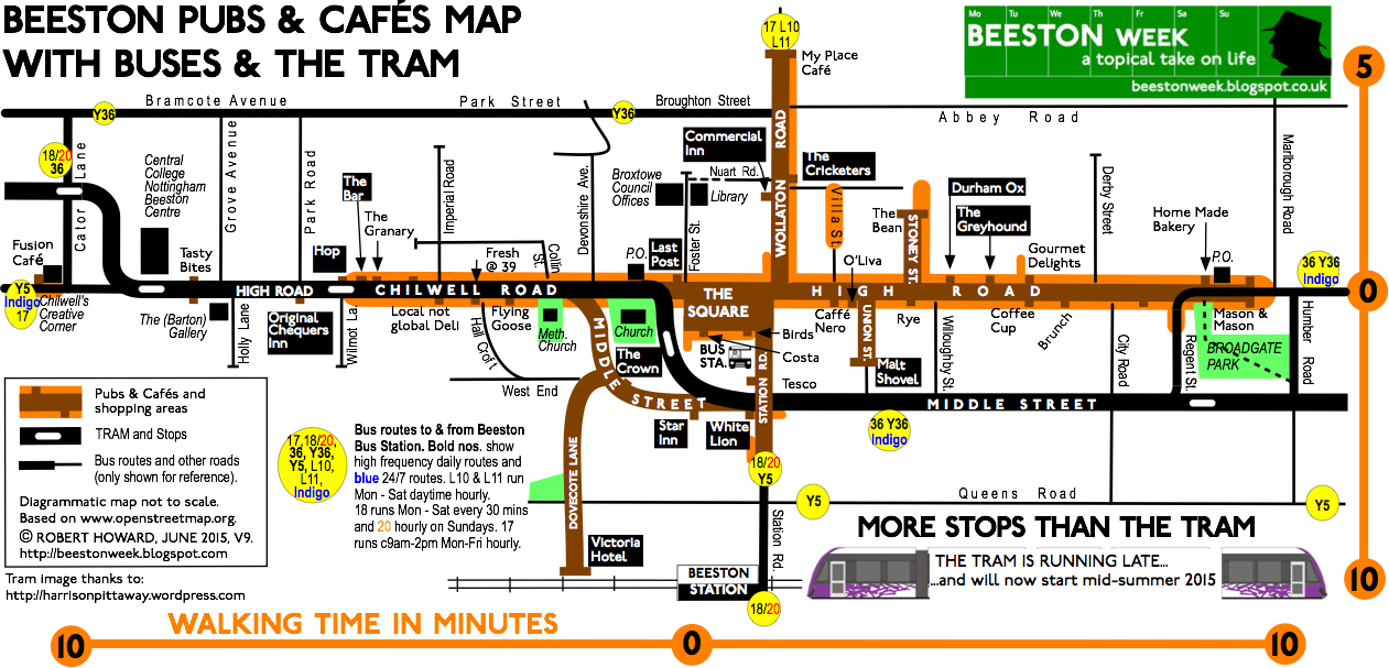

By now I was on a 9th version of the map and wanted to pull Beeston Lock onto the map so I could draw attention to the Beeston Canalside Heritage Centre project (which, at this point, still had to receive 2nd stage Lottery funding). Matt Turpin of The Beestonian also spoke about pulling the University into Beeston and Judy Sleath, the Chairman of Beeston Civic Society asked me if I could include blue plaque locations, so another, large version of the map came into being. It went from A4 to A3 and Judy funded the printing of 500 copies.


A 2015 Heritage Open Days version followed with Judy printing another 500 a month before the HODs.


A number of versions of this layout have subsequently been produced, but I always had in my head to create a vertical version because it would be easier to read and adapt, which is how a few months ago I arrived at this...

It hasn't taken me long to adapt this version, so that I could extend the map in the top left-hand corner...

As anyone who looks at this blog regularly will know I have created three versions of this map: the 'master' aimed at students, a 'heritage' version and a 'Beeston Nights' version, all of which can be found in the right-hand column. It has taken me three-and-a-half years to get this far and I have enjoyed creating the maps. Looking back, it is something I have been doing all my life, with my first map being published in 1976. Somewhere I have a copy.

All the maps have reverse text sides, the A3 ones with a Beeston Bus Map showing all the places you can reach by bus from Beeston (over a hundred). Again, you can find the latest version of the bus map in the right-hand column.

Anyway, that's it for now, all prompted by finding my very first Beeston Underground style map (which I had filed away on my computer in a directory labelled Beeston Writers).

Saturday, 30 July 2016

Updated Beeston pocket companion

This version of my Beeston map shows route changes to YourBus routes Y5 and Y36 as from 28 August 2016.

The Y5 will no longer serve Old Lenton, Abbey Bridge or Castle Boulevard. At Dunkirk Flyover the Y5 will turn north onto the Ring Road, then join the Derby Road and head towards the city centre via the QMC, Lenton Savoy Cinema and Canning Circus to Friar Lane (the Y5's existing city centre terminus remains unchanged.

The Y36 will follow its existing route from Nottingham city centre into Beeston along Middle Street until it reaches Station Road, where it will turn right and begin a anti-clockwise loop around Beeston, crossing Beeston High Road onto Wollaton Road, then turn left past Lidl onto Broughton Street, along Park Street to Cator Lane, then head south to Chilwell Road, before heading east along Chilwell Road to Beeston Interchange, then continue to the City Centre via Middle Street etc (the existing route)

The Y36 will no longer serve Inham Road, Field Lane or Bramcote Lane in Chilwell.


Just click on the map to enlarge. Its original size is A2 landscape with the aim of it being printed A3 landscape. This is the web version @ 96 lpi.


Sunday, 30 August 2015

Your Beeston bus and tram pocket companion updated

I have updated the Beeston Transport Map and called it a 'pocket companion' because it can be printed off and carried very easily. I have also marked some twenty-three out of Beeston places of interest, of of which can be reached directly by bus or tram. The railway from Beeston Station offers an almost endless list of places which can be reached in a couple of hours, including London, Leicester, Birmingham, Manchester, Sheffield, Norwich and so the list goes on.

Also included is information about buses and trams from Beeston Interchange.

Finally, remember this map has been design to print A4 landscape in with full colour or mono.  Simply click on the map to enlarge.

It has had its own page in the right-hand since I started this blog at there end 0f 2014.


Wednesday, 19 August 2015

Welcome to Your Pocket Companion to Beeston

Since I first created a Beeston Underground style guide to the town's pubs and cafés map in 2013, it has undergone a number of changes. I have described my latest version as a 'Pocket Companion to Beeston' and will incorporate a reverse side so that it can be published.  It has been created A3 landscape size, but prints perfectly well in A4 landscape, albeit the text and images are smaller, but readable. My maps are always created to print in mono as well as colour.

It now includes all Beeston's blue plaque locations and some additional shops. Feedback is always welcome. My aim is to have some printed copies available for the Beeston Heritage Open days weekend, 10–13 September 2015.


I think I can fairly claim to have been publishing the most up-to-date map of Beeston pubs & cafés there is since 2013 and today I have added Time for Tea Vintage Tearoom to the map. This wonderful tearoom is tucked away in a little end of terrace house on Wilkinson Street, right beside Broxtowe Borough Council offices


It is the creation of Emma Smith (left), who is being helped by her mum, Jane Blake (right). The are making cakes and selling loose leaf teas. Click on the picture to enlarge it and read today's menu!


You can find a link to Time for Tea on Facebook. I wish them well. The smell of baking cake from the back of the tearoom was so so teatime. Go soon. You won't be disappointed. This could become Beeston's answer to Nottingham's Lee Rosie Tearoom (opposite the Broadway Cinema).