In 1979 we bought a house beside Lenton Recreation Ground and in the years which followed canal walks took us, among other places, to Beeston Lock and onto Attenborough. The great thing, even then about canal walking, was the fact that it was all on the flat. In other words, no hills and even in my thirties I liked that.
Forty years on and so much has changed, so much more to see and do. The Attenborough Nature Reserve Centre, Beeston Marina, Lakeside (close enough for Beeston to claim as one of its attractions) and in just over a month the Canalside Heritage Centre will open.
Recovering from open heart surgery (now eleven weeks ago) I have found myself using Beeston Lock as a starting point for walks. Yesterday was one such day.
Until six months ago I would have walked to Beeston Lock, but right now if I walked from the top of Wollaton Road, where I live, I would get no further than the Lock, so I have been driving and parking on Canalside, as I did yesterday (there is a map at the end of this post showing route).
Click on the pictures to enlarge. They follow the direction of my walk.
Walking from Beeston Lock towards Beeston Marina with the River Trent beside you.
One of the odder sights is this outdoor launderette at Beeston Marina.
Just past the Marina on the right-hand side of the footpath you see this information board, where you turn right and walk away from the River Trent.
A lovely view of Beeston Pond to your right.
The path has Beeston Pond to the right and The Delta to the left. Ahead of you to the Meadow Lane railway foot crossing.
This glorious reed bed forms part of The Delta and can be seen from the left of the footpath.
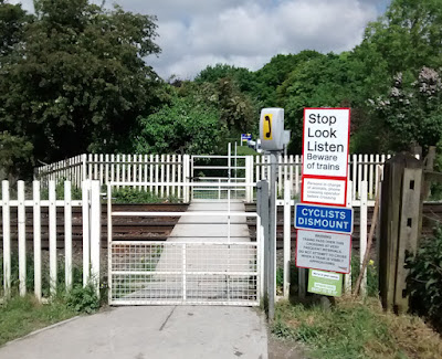
The Meadow Lane railway foot crossing which Network Rail wants to close. Lots of local folk and users have registered their objections to the proposal. Network Rail say the crossing is dangerous.
These two photographs show that few foot crossings can have such a clear view of oncoming trains as this one. Above is the view towards Beeston Station and below is the view towards Attenborough Station.
There is something primeval about this rotting tree beside the footpath away from the crossing towards Attenborough village.
The footpath towards Attenborough has a spur to the left towards what is Meadow Lane.
This is the clearest patch of open ground on the entire walk and...
...leads you onto to yet another footpath with water on either side.
On the west side of the path there is a clearing and a bench, where you can sit and look across the main pond towards Ratcliffe Power Station.
Where the main pond meets the River Trent there is this footbridge. When there has been a lot of rain it overflows into the Trent.
The bridge provides a pleasant place to stand and view the Trent.
On the day I was there, water from the main pond was roaring into the Trent.
One of the many directional signs you will find as you walk beside the Trent and around the Attenborough Nature Reserve. Notice this one points you to Meadow Lane, where this walk has come from.
Across the Trent at this point, the chalets on the opposite bank are actually in the City of Nottingham. You are about as far away as you can get from the city centre. At this point you are heading back towards Beeston Lock, which is about then minutes away.
We walked passed the Beeston Lock cottage at the beginning of the walk, but I wanted to use this photo to mark what is, in effect, the end of the walk.
This banner is fixed to wall of the new Canalside Heritage Centre. The building looks far from ready, but likes so many building projects the last bit happens in rush.
As I walked away from the lock and back down Canalside towards my car I saw another banner. This time advertising the Attenborough, Beeston & Chilwell Art Trail which takes place over the weekend 3–4 June 2017.
I hope this little map helps. I think the new Canalside Heritage Centre has great potential as a walking centre, from where you can go off in lots of different directions. The list of potential walks is considerable. For some time I have had a draft walking map centred on Beeston Lock in hand, but I have some walks yet to do.
We really do fail to appreciate what we have around us and this little walk I did today is a good example of this fact.
I also wonder if an occasional ferry (say the 1st weekend in every month) could link the two banks of the Trent so that you could visit Clifton Woods?
This area has great potential and could be linked in with other heritage/nature sites near by (Bramcote church tower, Nottingham Canal Nature Reserve, Wollaton Dovecote, Wollaton Hall & Park, Dunkirk Pond, Highfields Park, Lakeside, Toton Park & Mill site, Barton's vintage bus collection, Hurts, plus, of course, Beeston and Stapleford's numerous blue plaque locations). I rest my case, knowing I have left other locations out.
Urban walking opportunities get little attention and what we have in and around Beeston I would rank as being of national significance because it is so varied (the annual Heritage Open Days weekend in September demonstrate this fact).


No comments:
Post a Comment