

Showing posts with label map. Show all posts
Showing posts with label map. Show all posts
Wednesday, 24 July 2019

Thursday, 14 March 2019
Council Tax exempt student housing in Beeston map now showing numbers
The earlier map just showed locations and not how many properties at that location as defined by the postcode. These are overwhelmingly in Beeston.
I have now entered a number in the postcode pin on the map and entered an explanation on the map itself. The map is a good guide and I make no other claim for it. Six months from now the number will have increased as private landlords buy up more houses in Beeston to let to students, given the continuing restrictions in Nottingham. My aim over the last few years has been to demonstrate that you can map what is happening. At 70 I stopped doing committees and at 75 in a few weeks time I will let others worry about Beeston as I move onto more personal interests. I will help if asked but my self-volunteering days are really coming to an end after 60 years!
I do not doubt for one moment that the Lentonisation of Beeston continues apace.
I also believe Broxtowe Borough Council should work closely with students and other young people needing housing in the Borough to develop innovative housing schemes, which the young tenants would co-manage with others, ideally funding by a levy on landlords equal in value to any council tax exemptions they receive for existing properties. This money could be used to help secure funding to build housing in partnership with students and other young people. The way the present council tax exemption system works just means extra unearned income for landlords. Decent homes for all trump landlord profits.
Click on the map to enlarge:

I have now entered a number in the postcode pin on the map and entered an explanation on the map itself. The map is a good guide and I make no other claim for it. Six months from now the number will have increased as private landlords buy up more houses in Beeston to let to students, given the continuing restrictions in Nottingham. My aim over the last few years has been to demonstrate that you can map what is happening. At 70 I stopped doing committees and at 75 in a few weeks time I will let others worry about Beeston as I move onto more personal interests. I will help if asked but my self-volunteering days are really coming to an end after 60 years!
I do not doubt for one moment that the Lentonisation of Beeston continues apace.
I also believe Broxtowe Borough Council should work closely with students and other young people needing housing in the Borough to develop innovative housing schemes, which the young tenants would co-manage with others, ideally funding by a levy on landlords equal in value to any council tax exemptions they receive for existing properties. This money could be used to help secure funding to build housing in partnership with students and other young people. The way the present council tax exemption system works just means extra unearned income for landlords. Decent homes for all trump landlord profits.
Click on the map to enlarge:

Tuesday, 12 March 2019
Mapping Council Tax Exempt student property in the Broxtowe Borough Counccil area
The six maps below have been created using data listing 567 properties I received from Broxtowe Borough Council today. I will add comparative data in a few days.
If I can create these maps (and the earlier Beeston HMO Map below) with my very limited I.T. skills then it should be easy enough for others to do it better than me. For now I publish my maps without comment (click on a map to enlarge):
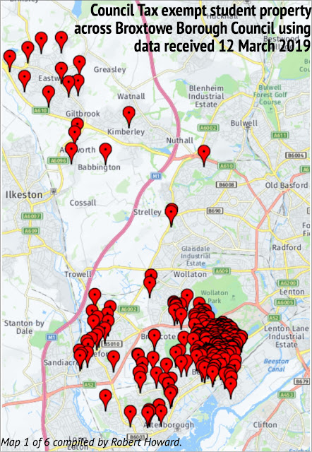


If I can create these maps (and the earlier Beeston HMO Map below) with my very limited I.T. skills then it should be easy enough for others to do it better than me. For now I publish my maps without comment (click on a map to enlarge):


At best the data has to be taken as a guide and needs more attention than I can presently give it. Compare the map of Beeston council tax exemption properties above with the map of Beeston HMOs below. Broadgate (pin showing 10) and Low Road (pin showing 14) in particular. This may a case of where multiple entries for the same postcode do not show up on the council tax exempt map — in other words my council tax exempt property map for Beeston should have more 'pins' than it does.


Thursday, 3 August 2017
Kegworth and Sutton Bonington Spider Map
I recently posted a map I have created for Nottingham University Students Union showing Kegworth village pubs and cafes etc. Below is my attempt at a 'spider map' which I prefer because it has allowed me to include Sutton Bonington village as well.
At the weekend my blog post will be about the visit last Saturday Susan and I made to the two villages so we could check out the first map. This map prints up really well A4 landscape — which is, of course 2 x A5 portrait pages.
I hope you find it of interest. Click on the map to enlarge.


At the weekend my blog post will be about the visit last Saturday Susan and I made to the two villages so we could check out the first map. This map prints up really well A4 landscape — which is, of course 2 x A5 portrait pages.
I hope you find it of interest. Click on the map to enlarge.


Wednesday, 3 May 2017
New look Nottingham City Centre Guide
I have been playing around with a grid like map of Nottingham city centre since 2013 and this is the latest version, which will be launched at the Nottinghamshire Local History Fair at Mansfield Central Library this coming Sunday.
To see in the map larger just click on the map. It prints off A4 portrait size extremely well and has been designed to print in mono as well as colour.

To see in the map larger just click on the map. It prints off A4 portrait size extremely well and has been designed to print in mono as well as colour.

If anyone thinks they might be able to use the map in some way please contact me for permission.
Robert Howard
Tuesday, 20 December 2016
Beeston Pond now on town heritage map
Thanks to web posts by Matt Turpin (Beestonia) and Anna Soubry (MP) I have picked up on Network Rail's proposed closure of the Meadow Lane foot crossing across the railway line between the Beeston and Attenborough railway stations.
Matt writes about the proposal with passion and I know enough from experience that arbitrary decisions can be defeated, and this proposal is clearly one of those.
One of my favourite Beeston walks takes me on a great loop around Beeston from my home off Wollaton Road and, as hard as this may be to believe, a month ago I had not worked out how to pull Attenborough Nature reserve into my vertical Beeston Heritage Map. Matt's post to his blog has prompted me to re-visit the problem and I have solved it by sacrificing the cover of the Civic Society's Blue Plaque Guidebook.
As I say I will return to this topic in the next few days. In the meantime, you can now find the Meadow Lane railway line foot-crossing on my map (in the top left-hand corner). As always, click on the map to enlarge:

Matt writes about the proposal with passion and I know enough from experience that arbitrary decisions can be defeated, and this proposal is clearly one of those.
One of my favourite Beeston walks takes me on a great loop around Beeston from my home off Wollaton Road and, as hard as this may be to believe, a month ago I had not worked out how to pull Attenborough Nature reserve into my vertical Beeston Heritage Map. Matt's post to his blog has prompted me to re-visit the problem and I have solved it by sacrificing the cover of the Civic Society's Blue Plaque Guidebook.
As I say I will return to this topic in the next few days. In the meantime, you can now find the Meadow Lane railway line foot-crossing on my map (in the top left-hand corner). As always, click on the map to enlarge:

Wednesday, 13 January 2016
Busting the Nottingham tram myth — bus and tram journey times in and around Nottingham
As I have admitted in my last two postings, I have a bee in my bonnet about the Nottingham tram and all the claims which are made on its behalf. Today, the Nottingham Post is at it again. This time it is actually pointing out that the Nottingham tram is down on its performance targets. Given that the network has doubled in size, it seems logical to expect more problems — simply because there are now more opportunities for delays, accidents etc.
I keep tweaking my map showing bus and tram journey times in and around Nottingham and surprise myself. A few who have seen the map have questioned its accuracy, because they find it hard to believe that the bus still has a quicker running time than the tram to Beeston, the QMC and Hucknall for example, and that the City Hospital is just a 11 minute bus ride from the city centre (Milton Street).
I have amended my Ruddington times from the city centre. Instead of the Victoria Centre, I have used the Angel Row timing point instead. This reduces the journey times. I have also changed the Ruddington Business/Country Park time to the hourly Kinchbus route 9.
I have printed off copies of all the timetables I have used and added a list detailing the routes etc. in the sidebar on their own page in the next few days.
The point is that all my journey times start in the city centre and the tram only shows the Old Market Square on its timetable downloadable as a pdf file.
Whatever way you look at it, the tram does not out-perform the bus in a number of ways: the bus is actually quicker (and you get a seat) going to Beeston, Hucknall and the QMC Derby Road entrance (the tram takes you direct to the QMC Treatment Centre on the south side of the QMC).
City Transport routes 68/69 from Bulwell may take 3 minutes longer to reach the city centre, but like the 36 and Y36 from Beeston, it stops right outside the Victoria Centre. Add on tram walking time (and factor in bad weather conditions on some days), the bus is simply a better option.
My page in the Post on Saturday explains why buses still have many advantages over the tram in Nottingham.
I could go on, but the aim of my unique map is to get you considering the facts for yourself, to check your own journey times and to look beyond the hype which surrounds the tram.

I keep tweaking my map showing bus and tram journey times in and around Nottingham and surprise myself. A few who have seen the map have questioned its accuracy, because they find it hard to believe that the bus still has a quicker running time than the tram to Beeston, the QMC and Hucknall for example, and that the City Hospital is just a 11 minute bus ride from the city centre (Milton Street).
I have amended my Ruddington times from the city centre. Instead of the Victoria Centre, I have used the Angel Row timing point instead. This reduces the journey times. I have also changed the Ruddington Business/Country Park time to the hourly Kinchbus route 9.
I have printed off copies of all the timetables I have used and added a list detailing the routes etc. in the sidebar on their own page in the next few days.
The point is that all my journey times start in the city centre and the tram only shows the Old Market Square on its timetable downloadable as a pdf file.
Whatever way you look at it, the tram does not out-perform the bus in a number of ways: the bus is actually quicker (and you get a seat) going to Beeston, Hucknall and the QMC Derby Road entrance (the tram takes you direct to the QMC Treatment Centre on the south side of the QMC).
City Transport routes 68/69 from Bulwell may take 3 minutes longer to reach the city centre, but like the 36 and Y36 from Beeston, it stops right outside the Victoria Centre. Add on tram walking time (and factor in bad weather conditions on some days), the bus is simply a better option.
My page in the Post on Saturday explains why buses still have many advantages over the tram in Nottingham.
I could go on, but the aim of my unique map is to get you considering the facts for yourself, to check your own journey times and to look beyond the hype which surrounds the tram.

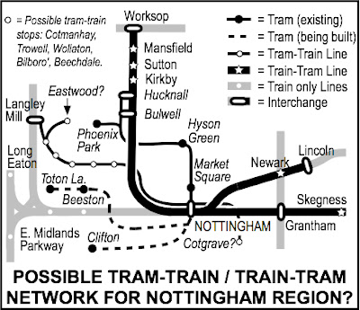
I believe there will be no more tram lines running along Nottingham streets. The long-term disruption in Beeston and Chilwell caused by tram construction work have soured attitudes towards new street tram lines. The future has to be with converting some existing railway lines to light-rail 'tram-trains' and there are plenty of opportunities for this (something I wrote about in the Nottingham Post in July 2013*). Here is the map I produced at the time:

As I always say, simply click on the map to enlarge and I do have pdf versions at 300dpi.
I could go on, but I think my maps speak for me and I have yet to see any comparable Nottingham public transport related maps.
The Robin Hood travelcard and Kangaroo ticket should cover the whole of the Nottingham travel to work area and this includes parts of Derbyshire and the City Council's efforts in this direction should be supported by Derbyshire and Nottinghamshire county councils. If or when we get a 'combined authority' including the Derby–Nottingham conurbation, the first task of the elected mayor should be the creation of a 'twin-city' public transport authority (PTA) to ensure we have just one universal travelcard like in London. It's quite simple if you have the will and commitment.
We shall see
NOTE: * Couldn't get link to story on Post website to work - sorry.
Wednesday, 7 October 2015
Beeston Oxfam venues map and a ride into the past
It's been two weeks since my last post because we went away for a week to Lowestoft in Suffolk. I was claiming a 70th birthday present from last year, which my daughter organised — a visit to the East Anglia Museum of Transport, so that I could ride on one of these...


... a old London trolleybus, aI almost certainly travelled on this actual trolleybus as a child and a teenager. I was seventeen when trolleybuses disappeared from Wembley, by which time I was travelling to work on a 662 six days a week in Harlesden. In fact, inside, beside the bench seat, the route information panel was for a 662.
Every year, on the last Saturday in September, the Museum stays open until 10pm, so that visitors can ride on trolleybuses in the dark. Our grown-up grand-daughters (aged 27 and 24) clearly enjoyed riding on trolleybuses and the occasional tram for hours and we had several trips on this particular trolleybus during the day.
I am a great fan of trolleybuses and feel blessed to have grown up using them every week. The ride in 2015 was as smooth and quiet as in the 1940s, 50s and early-60s, before they disappeared from London's streets for ever. We rode on trolleybuses from Derby, Newcastle and Bournemouth as well.
Our afternoon and evening at the Museum was the highlight of a very enjoyable holiday staying in Lowestoft — a place we will go to again, so that we can explore the town and its nearby neighbour, Great Yarmouth, more closely. Both are 'working' seaside towns and I enjoyed both far more than our visits to Cromer and, even, Southwold, where we holidayed for a few years until it was 'discovered' and it became too expensive.
Back home I have been putting the final touches to plans for the last Angel Row HistoryFest I am organising with Nottingham Local Studies Library, which takes place this coming Saturday (10 October) in the exhibition area on the 1st floor of Nottingham Central Library from 11am until 3pm.
Today I quickly produced a map for The Beestonian to help publicise the Beeston (music) Oxfam on Saturday 17 October. It shows all fifteen Oxfam venues:

Usual rule applies. Click on the map to enlarge.
There is plenty to write about once I get back into the swing of things and this coming Saturday marks a big milestone for me. I gave up on committees when I reached 70 last year and now just help, even if means I attend the occasional meeting. At 71 I have stopped organising things. I can do my maps, write and blog at my pace and help folks in ways I enjoy. No longer do I feel driven to do something because I believe I should.
Subscribe to:
Posts (Atom)